Tracker utilizes the GPS and data transfer capability of the gateway to record location and other related information on the AMM. These locations, along with data such as speed, direction (North, South, etc.) and time are used to show
current or historical gateway activity. As a gateway moves, its icon will also move on the map and will be shown at the head of its trail.
Vehicle icons, and clusters of vehicles are displayed on the map for gateways. For more information see: Map Tab
and Vehicles
.
Tip: Tracker’s map provides updates in near real-time, while the Map tab provides less frequent updates.
Tracker provides map and list views of the data, detailed reports, and the ability to export data for further analysis.
Tracker is currently targeted at the following markets:
EMS
Fire
Law Enforcement
Utilities / Large Commercial Fleets
Tracker is not designed as a full replacement for a Computer Aided Dispatch (CAD) system. It is a location tracking system designed for flexibility across verticals.
Notes:
As of AMM 2.15.2, Tracker is included as a core app. In oMM 2.15.1.1 and below, Tracker was provided as an optional add-on. For more information on Tracker as an add-on see: http://source.sierrawireless.com/devices/amm/tracker/
Tracker is available on the AMM but not the AM.
A manually set location is displayed on Tracker only when reporting within “All” is selected. Manually set locations are supported in AMM 2.16.2+.
For AMM 2.18, AirLink OS routers do not report speed data.
Tracker plots the geographical locations of all units/vehicles in a fleet or selected vehicles within a fleet as shown in the figure below:
Tracker Tab Plotting Locations
The following options are available/relevant to Tracker:
Tracker Tab Options
Filter: use to filter vehicles by name or group name.
Font Size: use this dropdown to select the size at which to display the gateway/cluster icon(s) on the map. This can be used to facilitate identifying the gateways. The default is 6pt.
Speed Trails: toggles whether or not the gateway’s trail, which indicates the device’s path of travel, is displayed on the map. Speed trails are colored according to the Speed Trail Legend at the bottom of the map, to indicate their speed.
Autocenter: by default, the map will automatically center the gateways on the map.
Zone: toggles whether or not any predefined zones should be displayed on the map. See Zones
for more information about authoring zones.
Traffic: displays traffic flow information on the map.
Find: locates an area on the map based on an address or a more general area (e.g. a city). The map will center on the address, but will not mark or indicate a specific location.
Autorefresh: toggles whether or not to update the gateways on the map periodically.
Refresh: forces a manual refresh of the gateways on the map.
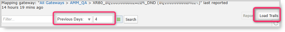
Use the drop-down menu to filter
vehicles by time since the previous report. Nominal events
(those operating within the threshold limits) are displayed by default (green square icon). De-selecting the green icon displays only those gateways in warning and error states.
Clicking in the purple arrow
displays only the gateways that have moved in the last 5 minutes.
Tracker Reports
Reports provide the true power of the AMM. Tracker-related reports are designed to be broad, with data export capability to allow for further analysis.
Notes: In AMM 2.18, there are no Tracker reports available for AirLink OS routers. Use the Map tab time filter options and the Load Trails button to review past information.
Viewing trails
To generate Tracker reports, navigate to Reports > Tracker.
Reports that are related to Tracker include:
Gateway Trip Trend - shows the distance traveled per gateway per time unit including time spent moving and (related) average speed. This report is useful in identifying trends in vehicle usage across a fleet of vehicles.
Gateway Trips - plots the gateway location as a trail (continuous line) on the map (i.e. the route the vehicle traveled). This report is most useful for a single gateway over a relatively short period of time (e.g. one gateway trip) where the same location is not visited repeatedly.
Gateway Trip Coverage - plots a coverage map of locations visited by vehicles and uses color to represent the time spent in the area.
Trip Replay - animates a gateway trip over the time period selected. As the gateway (represented by a marker) moves over the map, it is followed by a colored trail which indicates speed and distance covered. The report is a
spatial representation of gateway location history that is not available on the Gateway Trip report. It is useful for analyzing how often gateways cross paths with each other.
Zone Summary - provides a summary of time spent, as a percentage, in different zones across one or more units.
Zone Times - provides a time-based, visual representation of the zones visited by a gateway. The report is best used for a single gateway over a short period of time (one day is optimum) or as an in depth view to the Zone Summary report. It is useful for fleet managers who assign gateways to zones to monitor utilization.
Zone Map - reports the locations of a single gateway over a specific time period.
For detailed information on using and configuring reports, see: Reports
.
Configuring a Tracker User Account
Tracker user accounts are modified AMM user accounts, assigned by AMM administrators. Tracker users are typically only interested in a fraction of the AMM’s functionality and the AMM administrator should customize the Tracker
account for this purpose. A recommended set of features are:
Dashboard tab: Customize the visible thresholds to display only the Zone indications so that other threshold conditions do not conflict with the zone threshold.
Event tab: Useful to display historical locations.
Tracker tab: Required to use the Tracker feature.
Basic Viewing and Operation
Tracker must be activated for each AMM account to be a visible tab in the AMM. Additionally, each gateway to be tracked must be set up to report GPS and related data at the correct frequency. Contact Sierra Wireless Technical Support
for further details or to confirm that this has been completed for a particular gateway.
To view the Tracker dashboard, click on Tracker in the AMM menu:
Location of Tracker Tab
Navigating within Tracker
The following navigational element’s of the AMM are used for Tracker:
Main elements of AMM interface used for Tracker
Gateway List: used for selecting and filtering gateways to view with Tracker. For more information see Gateway Tree
.
Main Tabs: used for selecting Tracker.
Main Menu Controls: the following main menu controls are available:
Font size dropdown: Controls the size of the font for the gateway indicators on the map.
Speed trails: Toggles whether color-coded lines are shown indicating the speed of each gateway over its journey. When enabled, a legend is also shown at the bottom describing the speeds corresponding to each color.
Autocenter: Centers the gateway(s) on the map. If the map is set to refresh automatically, or is refreshed manually, the map re-center itself if a gateway reaches the edge of it.
Zones: Toggles predefined zones on and off. Zones are virtual geofences which track when gateways leave or enter a defined area. See Zones
for more information.
Traffic: Some mapping providers supply local traffic information. Check with your preferred mapping provider for more details about traffic information availability in your area.
Find: Used to locate a street address or a general area on the map.
Autorefresh (clock icon): When enabled, the browser page is automatically updated (default is 30 seconds).
Refresh: Manually refreshes the map with the latest gateway location.
 Searching...
 Filter: use to filter vehicles by name or group name.
 Font Size: use this dropdown to select the size at which to display the gateway/cluster icon(s) on the map. This can be used to facilitate identifying the gateways. The default is 6pt.
 Speed Trails: toggles whether or not the gateway’s trail, which indicates the device’s path of travel, is displayed on the map. Speed trails are colored according to the Speed Trail Legend at the bottom of the map, to indicate their speed.
 Autocenter: by default, the map will automatically center the gateways on the map.
 Zone: toggles whether or not any predefined zones should be displayed on the map. See Zones
for more information about authoring zones.
Zone: toggles whether or not any predefined zones should be displayed on the map. See Zones
for more information about authoring zones. Traffic: displays traffic flow information on the map.
 Find: locates an area on the map based on an address or a more general area (e.g. a city). The map will center on the address, but will not mark or indicate a specific location.
 Autorefresh: toggles whether or not to update the gateways on the map periodically.
 Refresh: forces a manual refresh of the gateways on the map.
 vehicles by time since the previous report. Nominal events
  (those operating within the threshold limits) are displayed by default (green square icon). De-selecting the green icon displays only those gateways in warning and error states.
 displays only the gateways that have moved in the last 5 minutes.